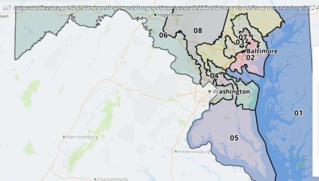
Advanced statistics and redistricting reformers combined to kill one of the country’s worst gerrymanders.
Calling it “an extreme gerrymander,” a Maryland judge on Friday tossed out the state’s new congressional district map and ordered state lawmakers to produce a new one before the end of the month. In the ruling, Judge Lynne A. Battaglia said the eight congressional districts drawn by the Democrat-controlled state Legislature lacked compactness and demonstrated a disregard for existing political boundaries like counties and cities. The map “subordinates constitutional criteria to political considerations,” Battaglia wrote, and in doing so violates the Maryland Constitution’s equal protection and free elections clauses. It’s the first time in Maryland history that a judge has discarded a redistricting map for being too politically slanted, according to The Washington Post, which is really saying something given the state’s recent history. The congressional map used in Maryland for the past 10 years was one of the most highly gerrymandered in the country—even though Republican gerrymanders in places like North Carolina, Pennsylvania, and Wisconsin attracted more attention to the problem of politically motivated mapmaking. That’s part of the reason why Maryland’s congressional delegation has been split 7–1 in favor of Democrats for the past decade. This time around, Democrats in Annapolis drew an even more gerrymandered map that would have given them an electoral edge in all eight of the state’s districts by carving up Maryland’s deep blue Baltimore/Washington corridor so that nearly all of the state’s congressional districts include some part of it. The new map received a grade of “F ” from the Princeton Gerrymandering Project, which grades congressional maps on partisan fairness, geographical compactness, and other factors. In the ruling, Battaglia pointed to how the Maryland map scored poorly in several metrics used to access the compactness of political districts. These mathematical formulas are imperfect ways of assessing congressional districts—not every district ought to be a perfect circle, of course. But, as I argued in a 2018 feature for Reason, that sort of statistical analysis is vital for lawmakers and judges to use when assessing the question of how much gerrymandering is too much.


