▶ Watch Video: Hurricane Debby makes landfall in Florida as Category 1 storm Tropical Storm Debby was barreling.
Tropical Storm Debby was barreling across northern Florida on Monday morning after making landfall over the state’s Big Bend coast as a Category 1 hurricane. Even with the slight dip in intensity, Debby was forecast to bring severe and possibly monstrous storm surge — as high as 10 feet above ground level in some areas — to parts of the Gulf Coast of Florida.
The storm could bring historic rainfall to surrounding states like Georgia and South Carolina, too, the National Hurricane Center said, warning that Debby was expected to cause “major flooding” to parts of the southeastern United States over the next several days.
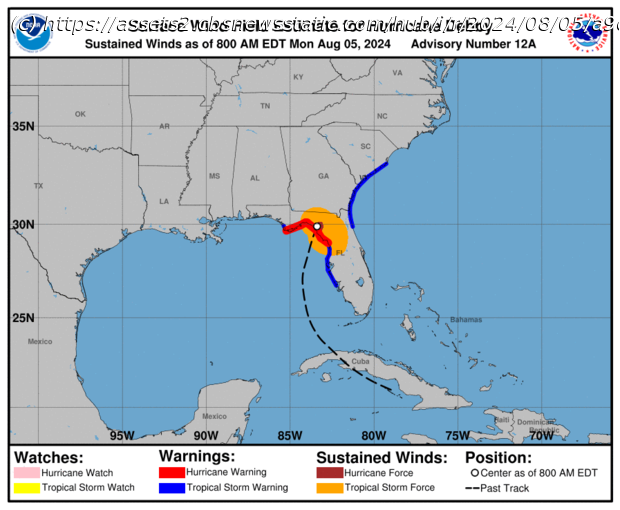
Debby slammed into the Big Bend coast, where the Florida panhandle meets the peninsula, near Steinhatchee, a small oceanside town about 70 miles west of Gainesville, at around 7 a.m. EDT. The hurricane center said it was was tracking slightly inland in the Big Bend region about an hour after landfall, with maximum sustained winds of 75 miles per hour. That marked a marginal decrease in power, as meteorologists estimated that Debby struck the coast with 80 mph winds.
By 11 a.m., sustained wind speeds had fallen to about 70 mph, with higher gusts, as the tropical storm churned along its anticipated route north. Meteorologists said at the time that Debby was located about 35 miles west of Lake City, Florida, and about 120 miles south of Valdosta, Georgia. The storm was expected to gradually weaken over the coming days.
Meteorologists expected that storm surge would be most catastrophic in the immediate vicinity of the landfall location, with initial forecasts indicating a 130-mile stretch of coastline between Yankeetown and the Aucilla River could see surges between 6 and 10 feet above ground. Ten feet is almost as tall as a traditional ranch-style building.
The National Hurricane Center published a map Monday morning illustrating the storm surge forecast.
Home
United States
USA — Science Maps show Tropical Storm Debby's path and forecast – WSGW 790 AM...


