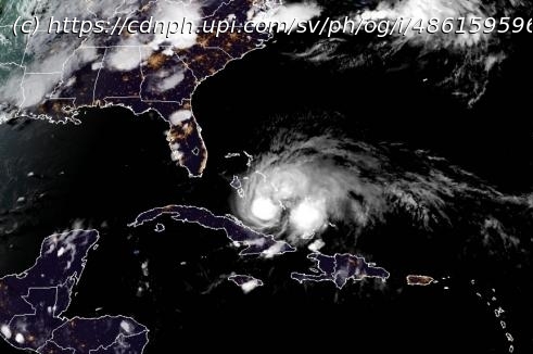
Government officials and residents in Florida were in full preparation mode on Friday as Hurricane Isaias pounded the Bahamas with strong winds and heavy rains, and moved closer to the U. S. mainland.
July 31 (UPI) — Government officials and residents in Florida were in full preparation mode on Friday as Hurricane Isaias pounded the Bahamas with strong winds and heavy rains, and moved closer to the U. S. mainland.
Isaias was packing 75-mph winds late Friday afternoon, down from its peak sustained winds of 80 mph earlier in the day.
Florida Gov. Ron DeSantis declared a state of emergency in every coastal county of Florida’s Atlantic Coast, stretching from Miami-Dade to Nassau counties, on Friday in preparation for the storm. Friday evening, Virginia Gov. Ralph Northan also issued a state of emergency.
Meanwhile, the National Hurricane Center issued a hurricane warning for portions of Florida’s Atlantic coast.
Residents in Florida were bracing for impact and stocking up on essentials ahead of Isaia’s potential arrival, all while wearing masks — a sign of the confluence of hurricane season with a global pandemic.
Tropical Storm Isaias strengthened into Hurricane Isaias late Thursday and approached the Bahamas early Friday, on track to bring heavy rains and wind to the eastern coast of Florida this weekend.
The National Hurricane Center said in its 5 p.m. update Friday the storm was 195 south-southeast of Nassau and 330 miles southeast of Freeport, Grand Bahama Island. Isaias had maximum sustained winds of 75 mph and was moving northwest at 15 mph.
Hurricane warnings were in effect for the Bahamas on Friday, including hard-hit areas from Dorian in 2019 like the Abaco Islands, although meteorologists expect the impacts to pale in comparison to the monster storm that stalled for 24 hours and caused utter devastation there last year.
“Isaias is expected to be a 1 on the AccuWeather RealImpact Scale for Hurricanes in the Bahamas and the coastal southeastern U. S. due to flooding and damaging winds,” AccuWeather senior meteorologist Rob Miller said.
This scale is a more nuanced method the company introduced in 2019 to assess the potential damage a tropical system could cause.
It has been 25 years since a hurricane tracked through the Bahamas so early in the season, specifically prior to the middle of August. Erin strengthened into a Category 1 hurricane near Rum Cay in the Bahamas and moved through the island chain on Aug. 1-2,1995, according to Colorado State tropical meteorologist Philip Klotzbach. The storm passed over the Abaco Islands and Grand Bahama, causing generally minor damages, before heading toward Florida.
Isaias’ recent strengthening will help the hurricane forge a track more to the north. And the system could potentially strengthen even more over the very warm waters of the Gulf Stream, especially since Isaias is now expected to avoid the large land mass of Cuba this weekend. Forecasters have ruled out a track toward the Gulf of Mexico with these developments.
Conditions will deteriorate rapidly from south to north over the Bahamas and the eastern part of the Florida Peninsula this weekend as Isaias takes a northwestward, then northward path over the warm waters of the Gulf Stream. How far west versus east Isaias tracks and exactly how strong and large the eye wall becomes will determine the severity of conditions in the Bahamas and along the Florida Atlantic coast.
Tropical storm warnings remained in effect for the Turks and Caicos.
The National Guard released dramatic flood rescue video from Puerto Rico, showing young children and infants being pulled from high waters left behind after Isaias’ torrential downpours. Parts of the island picked up more than 10 inches of rain as Isaias moved just south of the island on Thursday.
AccuWeather meteorologists expect Isaias to fluctuate in strength through this weekend with intensity ranging from a Category 1 hurricane to a tropical storm and perhaps as strong as a Category 2 hurricane for a time. A Category 1 hurricane has winds ranging from 74 mph to 95 mph, while a Category 2 hurricane has winds of 96 mph to 110 mph. A tropical storm has winds of 39 mph to 73 mph.
Isaias will be moving over water that is very warm this weekend, with temperatures ranging from 84 degrees to 90 degrees Fahrenheit, which is more than sufficient to allow for abrupt strengthening.


