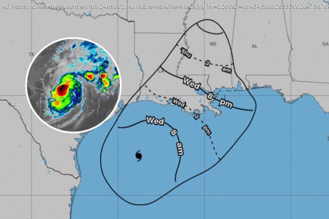
The system, due to slam into the Louisiana coast later on Wednesday, has wind speeds of about 90 mph, and is forecast to cause large amounts of damage.
As Hurricane Francine approaches the Gulf Coast, its powerful winds are about to start lashing against Louisiana, Mississippi, and Texas.
The Category 1 hurricane, which upgraded from a tropical storm on Tuesday, is expected to batter the Gulf Coast with intense winds of up to 100 mph, heavy rain, and powerful storm surges, leaving some regions “uninhabitable for weeks or months.”
These powerful tropical-storm-force winds are due to hit the coast of Louisiana just before 2 p.m. local time on Wednesday, before swooping across the state and hitting the Mississippi border by about 8 p.m. on Wednesday evening, a National Hurricane Center (NHC) map shows.
More From Newsweek Vault: Learn the Fastest Ways to Build an Emergency Fund Today
Hurricane Francine was about 150 miles southwest of Morgan City, Louisiana, as of 10 a.m. local time, with wind speeds approaching 90 mph.
“Reports from Air Force Reserve and NOAA [National Oceanic and Atmospheric Administration] Hurricane hunter aircraft indicate that maximum sustained winds are near 90 mph (150 km/h) with higher gusts. Little change in strength is expected before landfall”, the NHC said in a public advisory.
“Hurricane-force winds extend outward up to 40 miles (65 km) from the center and tropical-storm-force winds extend outward up to 115 miles (185 km).
Home
United States
USA — Science Hurricane Francine: Arrival Map As Areas To Be 'Uninhabitable for Weeks'


