Those near “major polluters in Milton’s trajectory might face the true disaster in the aftermath of the storm,” a researcher said.
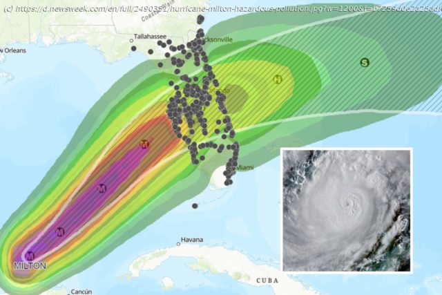
As Hurricane Milton approaches Florida’s coast, it is expected to bluster over many of the state’s major hazardous material facilities, which are major sources of pollution.
A map by Rice University’s Center for Coastal Futures and Adaptive Resilience (CFAR) reveals the major polluters—included on the U.S. Environmental Protection Agency’s 2022 Toxic Release Inventory—in the path of the oncoming storm.
When the storm hits these sites, there are fears that the pollution may be distributed far and wide by the powerful winds and the intense rainfall.
“Unfortunately, as past storms have shown us, those residing near the major polluters in Milton’s trajectory might face the true disaster in the aftermath of the storm”, James Elliott, co-director of CFAR, department chair and the David W. Leebron Professor of Sociology at Rice, said in a statement.
These sites include concrete plants, electronic manufacturers and chemical plants, among many other facilities.
When hurricanes hit facilities like these, the combination of powerful winds, storm surges, and flooding can damage storage tanks, pipelines, and containment systems, causing hazardous substances to be released into the environment. Floodwaters may also wash chemicals, oil or industrial waste into rivers, lakes or oceans, which can have serious impacts on aquatic life and pose risks to human drinking water sources.
Hurricanes can cause fires or explosions at industrial sites, releasing toxic fumes and particulate matter into the air.
Home
United States
USA — Events Hurricane Milton: Florida Map Reveals Hazardous Facilities in Storm's Path


