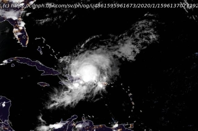
After pummeling Puerto Rico, the Dominican Republic and Haiti with torrential downpours and power-cutting winds, Tropical Storm Isaias is forecast to take a northwesterly path roughly between Cuba and the Bahamas.
July 30 (UPI) — After pummeling Puerto Rico, the Dominican Republic and Haiti Thursday with torrential downpours and power-cutting winds, Tropical Storm Isaias is forecast to take a northwesterly path roughly between Cuba and the Bahamas late this week, before taking a potential track right along the Eastern Seaboard of the United States. Tropical Storm Isaias, pronounced ees-ah-ee-ahs, was upgraded from Potential Tropical Cyclone Nine status by the National Hurricane Center at 11 p.m. EDT Wednesday. The system strengthened as it developed a more organized center with thunderstorms wrapping around its core — and Isaias became the earliest „I-storm“ in recorded history. The prior record holder was Irene from Aug.7,2005. Isaias could become the second named system to make landfall in the United States in about a week following Hanna’s arrival in South Texas on Saturday. „There is a chance that Isaias may make landfall over the Florida Peninsula this weekend, although the possibilities of tracks range from a path into the eastern Gulf of Mexico to a near-miss or glancing blow along the southern Atlantic coast of the U. S. into next week,“ AccuWeather senior meteorologist Rob Miller said. As of 2 p.m. Thursday, Isaias was churning right along the southern coast of the Dominican Republic with maximum sustained winds of 60 mph and was racing northwestward at about 20 mph. The storm was located about 95 miles west-northwest of Punta Cana, Dominican Republic. The center was crossing the island of Hispaniola, which consists of the countries of Haiti and the Dominican Republic, and is likely to emerge along the northern coast of the island during Thursday evening. Miller stated that people should not focus on just the eye path at this point as tropical-storm-force winds extend outward by about 310 miles from the center on the storm’s northeastern, northern and northwestern flanks. When compared to that of tiny Gonzalo from last week, the tropical-storm-force winds extend farther out from the center by 285 miles. Torrential downpours, gusty thunderstorms and building seas are likely to precede Isaias by as much as 24 hours, which means that tropical storm conditions will spread northwestward across the Bahamas and Cuba during Thursday night, Friday and Saturday and should begin in Miami during Friday night or early Saturday morning. Tropical storm conditions could then spread across the state over the weekend. Adding to what forecasters expect to be rapidly deteriorating conditions ahead of the sprawling tropical storm is the fact that the system is racing along at approximately twice the average speed of tropical systems for this area of the basin. All interests from the Dominican Republic and Haiti to Cuba, the Bahamas, Bermuda, the eastern United States and Atlantic Canada are urged to monitor the progress of Isaias.


