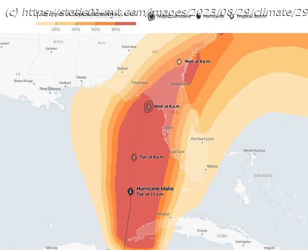
Idalia’s path makes it difficult to predict where the storm will come ashore.
Hurricane Idalia continued to build strength over the Gulf of Mexico’s abnormally warm waters on Tuesday, taking aim at a vulnerable but sparsely populated portion of Florida’s coastline known as the Big Bend, where the peninsula curves west into the Panhandle.
Idalia’s path, which is expected to run parallel to Florida’s western coast for much of Tuesday, makes it difficult to predict exactly where the storm would come ashore: A little wobble to the east or the west could move its center toward Tallahassee to the north or Tampa to the south.
My colleagues and I on The Times’s Weather desk just redesigned our hurricane tracker with detailed information about the storm’s path and severity.
In today’s newsletter, I’m going to tell you how best to track a hurricane’s progress, especially if you’re in its path. I have nearly two decades of experience covering natural disasters like these, and there are a few things I’ve learned:
Don’t focus too much on the center of the storm: Many people look only at the “cone of uncertainty” — the familiar map that shows the likely path of the hurricane’s eye. But people often misinterpret these maps, thinking they’ll be safe if they live just outside the cone, for example. (See this 2019 article from Times Opinion for more.) Nearly a year ago, officials in Florida’s Lee County saw they were on the edge of the cone of uncertainty for Hurricane Ian and delayed an order to evacuate, with devastating consequences.
Tropical storm-force winds can be deadly, too. You can be well outside the forecast path of the hurricane and still experience deadly wind, rain and storm surges. Tropical storm-force winds typically arrive as conditions begin to deteriorate, so their estimated arrival time is a good deadline for completing storm preparations and evacuating if asked to do so. We’ve updated our hurricane tracker to track that information.
Beware the front right quadrant of the storm. Because hurricanes move counterclockwise in the Northern Hemisphere, that’s the area that will receive more wind, water and storm surges.


